Ecology, Part 2 (outdoor option): Introduction to the Sandy Intertidal Ecosystem
Objectives
Describe the causes of tides and their effects on the organisms that live in the tidal zones
Distinguish between biotic and abiotic factors and provide a list of each
Describe the different types of biogeochemical cycles such as the nitrogen, carbon and phosphorous cycles
Use iNaturalist to identify organisms living in different tidal zones
This lab includes pre-lab activities, activities that can be done at the James C. Goetz Aquarium and Kingsborough beach, and activities that can be done after returning to the lab from the field.
I. Sandy Intertidal Ecosystem
We have been learning how ecosystems function: food webs and trophic structure, community interactions such as predation and competition, and nutrient cycling. This lab will introduce you to one of our local ecosystems, the sandy intertidal—or as we more commonly call it—the beach. You will learn about and observe aspects of the abiotic environment, biodiversity, trophic relationships, and nutrient cycling.
You will visit the James C. Goetz Aquarium and the Kingsborough Beach with your instructor, who will explain the causes of tides and their effects on the intertidal environment. Most notably, you will see how the tides create zones, and each zone contains a distinct set of organisms adapted to the unique conditions in that zone.
Pre-lab Activities
Figure 1 below and the videos that follow may be helpful to review before you go.
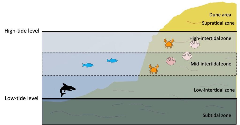
Start at 3:30 for an explanation of zonation.
iNaturalist
Before you leave the lab, your instructor may also wish to introduce you to an app called iNaturalist that you will use for this lab activity. You may visit their website and sign up for a free account there or download the free iNaturalist app onto your mobile device. You can also download a simplified guide written by KCC Prof. Christina Colon, “iNaturalist How To.”
This app allows you to upload images of the organisms you observe wherever you are, and they can be identified and classified by you or other users. In this way, you contribute to a global database of biodiversity observations. You can also access the database to see what organisms other people have found in your area. You can even investigate research questions such as “How many invasive crab species exist in New York Harbor?” or “When were invasive crabs first recorded in New York Harbor?” Your instructor will show you how to use the app.
A Local Food Web
You may have already learned about food webs and trophic pyramids. Your instructor may decide to show you this presentation created by educators at the Billion Oyster Project, which gives many details about the food web in our local marine ecosystem.
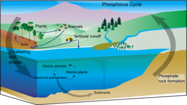
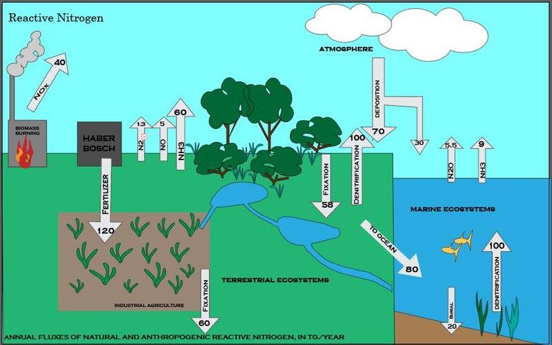
The Phosphorus and Nitrogen Cycles
While at the beach, you may collect water samples to assess water quality and to learn more about nutrient cycles in ecosystems (also called biogeochemical cycles). For this lab, we will test nitrate and phosphate in the water (among other variables). The diagrams (Figures 2 and 3) and videos below may be helpful for understanding the phosphorus and nitrogen cycles.
Key Terms
| Term | Definition |
| Abiotic factors | Environmental factors that do not result from living things, such as precipitation, wind, temperature, soil type, oxygen saturation, salinity, fire, etc. |
| Biotic factors | Environmental factors that result from living things, such as competition, predation, and symbiosis |
| Ecological niche | The total resources that a species requires for its survival |
| Intertidal zone | The coastal area that is above water at low tide but under water at high tide |
| Tidal zones | The zones within the intertidal that are defined by differing abiotic and biotic conditions that depend on how long each zone spends out of the water during each tidal cycle |
| Tidal cycle | The cycle of high tide and low tide, which usually includes two high tides alternating with two low tides in each 24-hour day. (high-low-high-low) |
| Biogeochemical cycle | The pathway by which a substance such as carbon, water, or nitrogen cycles through the abiotic and biotic components of an ecosystem |
| Biodiversity | The variety of life in a given location, including genetic, species, and ecosystem diversity |
II. Activities
Activity 1: Visit the James C. Goetz Aquarium
As you may know, the James C. Goetz Aquarium is located in the Marine Academic Center (MAC) at Kingsborough. There are many helpful exhibits there, including a detailed model of a sandy intertidal ecosystem similar to the beaches surrounding New York City. Try to identify the tidal zones in this exhibit.
Next, choose an organism from the exhibit and use its number to look it up in the online booklet “Marine Life.”
Answer the questions below. If time allows, your instructor may require you to choose a second organism to investigate.
- Which zone does your organism live in? Approximately what percentage of the day is spent out of the water in this zone?
- Is your organism motile or sessile? How does this affect which zone(s) it can occupy?
- What specific adaptations does your organism have that allow it to survive in that zone? Include adaptations that relate to being underwater, as well as those that relate to the amount of time the organism spends out of the water at low tide.
- What is the trophic level of your organism? How does it obtain food, and what other organisms consume it? If you cannot answer this right now, simply take a picture of the organism. You can look up more details about it once you are back in the lab.
Activity 2: Visit to the Kingsborough Beach
Weather permitting, we will take a walk to the Kingsborough beach located behind the cafeteria, where we will make additional observations and collect samples to take back to the lab. Along the way, your instructor may point out organisms and distinct habitat features of the intertidal that can be seen from the path along the seawall. You can also use iNaturalist to identify and catalog the organisms you see.
Once at the beach, please note the following important safety guidelines:
- Students must not enter the water at any time.
- Do not walk or climb on the rocks. Remain on the sand.
- Stay with the group.
- Be cautious when picking anything up from the beach, as sometimes broken glass or other sharp or potentially harmful objects may wash up on the sand.
- Check with the instructor before collecting any organisms or samples.
- Follow all instructions from your instructor and from Public Safety officers.
- Do not leave any trash or other items on the beach. Leave it cleaner than you found it!
- Wash your hands with soap and water upon returning to the lab.
While you are at the beach, think about and try to answer the following questions:
- The Kingsborough beach is a good example of a sandy intertidal ecosystem. It can be difficult to observe intertidal zonation on a sandy beach. Can you explain why this might be?
- The beach is bordered by a rock jetty at each end, and there we can more easily observe many aspects of tidal zonation, depending on the tidal level at the time of our visit.
- Why is it easier to observe zonation on a rocky surface?
- When do you think is the ideal time to observe tidal zonation: low tide, or high tide? Explain your answer.
- Most of the organisms you see are likely to be dead rather than alive, washed onto the sand by the tide. What features can you observe on these dead organisms that may help you to determine what zone it belongs in? For example, what adaptations are needed in the high intertidal zone that are not as important to survival in the low intertidal zone?
Locate and take pictures of as many species as you can. You will identify the species once you are back in the lab.
Following instructions from your instructor, collect water samples and conduct the following water quality tests: salinity, pH, dissolved oxygen, temperature, nitrate, phosphate, and turbidity. Record your findings.
As directed by your instructor, you may collect specimens to bring back to the lab for closer observation. These may be living or dead (such as shells). Any living specimens will be returned to the beach after observation. Be sure to transport aquatic creatures in a container with adequate seawater to keep them alive and happy.
Activity 3: Laboratory Observations and Analysis
Once back at the lab, compile a class list of all the species you observed at the Goetz Aquarium in the sandy intertidal exhibit. Confirm the trophic level for each species and work together to draw a basic food web for this intertidal ecosystem. You may want to refer to the booklet, “Marine Life,” or the New York Harbor Food Web presentation.
Use the dissecting microscopes as guided by your instructor to examine the morphology and behavior of the organisms you collected at the beach. Be sure to identify each organism and its trophic level (see below).
You may also refer to a species ID guide published by the Billion Oyster Project. You can also use iNaturalist and/or the Marine Life booklet to help identify the organisms you observe.
As a class, catalog the species biodiversity found on the beach (include both living and dead organisms). Use the species ID booklet to identify the trophic level of each organism you found. Then combine your observations as a class and construct a food web for the KCC beach ecosystem.
- How does the food web for the KCC beach compare to the food web you made for the Goetz Aquarium sandy intertidal exhibit? List the similarities and differences, and propose a hypothesis to explain the differences. (In other words, what do you think causes the differences?)
Retrieve water quality the data you obtained at the beach. Compare these values to the standard values for marine ecosystems, such as those found in this document.
- How does the water quality at Kingsborough compare to standard values? Is the quality higher or lower than these standards? Can you propose a hypothesis to explain any differences in water quality?
