74 Coastal Geology: Shorelines
Beaches
A beach is a landform along the coast of an ocean or sea. It usually consists of loose particles, which are often composed of rock, such as sand, gravel, shingle, pebbles, or cobblestones. The particles comprising a beach are occasionally biological in origin, such as mollusc shells or coralline algae.
Beaches typically occur in areas along the coast where wave or current action deposits and reworks sediments.
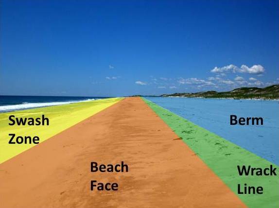
There are several conspicuous parts to a beach that relate to the processes that form and shape it.
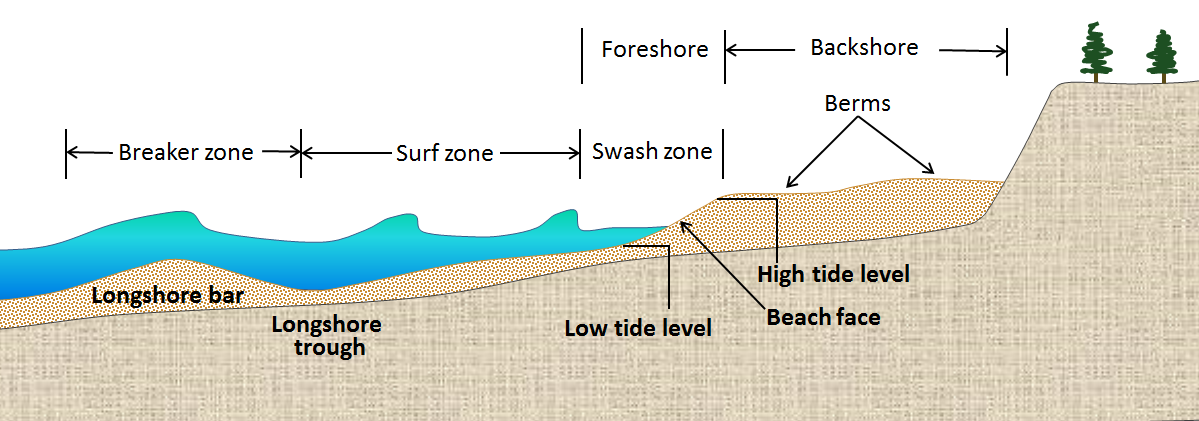
- Swash zone: is alternately covered and exposed by wave run-up.
- Beach face: sloping section below berm that is exposed to the swash of the waves.
- Wrack line: the highest reach of the daily tide where organic and inorganic debris is deposited by wave action.
- Berm: Nearly horizontal portion that stays dry except during extremely high tides and storms. May have sand dunes.
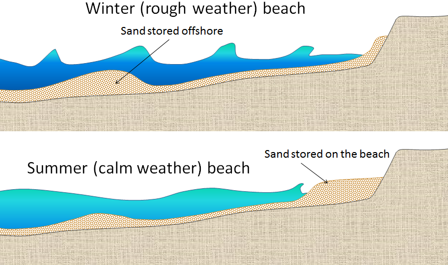
The beach profile changes seasonally due to the change in wave energy experienced during summer and winter months. In temperate areas where summer is characterised by calmer seas and longer periods between breaking wave crests, the beach profile is higher in summer. The gentle wave action during this season tends to transport sediment up the beach towards the berm where it is deposited and remains while the water recedes. Onshore winds carry it further inland forming and enhancing dunes.
Conversely, the beach profile is lower in the storm season (winter in temperate areas) due to the increased wave energy, and the shorter periods between breaking wave crests. Higher energy waves breaking in quick succession tend to mobilise sediment from the shallows, keeping it in suspension where it is prone to be carried along the beach by longshore currents, or carried out to sea to form longshore bars, especially if the longshore current meets an outflow from a river or flooding stream. The removal of sediment from the beach berm and dune thus decreases the beach profile.
Source: https://opentextbc.ca/geology/chapter/17-3-landforms-of-coastal-deposition/
Cliffs
A cliffed coast, also called an abrasion coast, is a form of coast where the action of marine waves has formed steep cliffs that may or may not be precipitous.
In coastal areas in which the land surface dips at a relatively steep angle below the water table, the continuous action of marine waves on the coastline, known as abrasion, may create a steep slope known as a cliff. Its slope angle depends on a variety of factors including the jointing, bedding and hardness of the materials making up the cliff as well as the erosional processes themselves.
The slope is constantly being eroded. The waves attacking the cliff-foot form a wave-cut notch by constant abrasion action producing an overhang. This overhang grows in size as the cliff is undercut, until it collapses under its own weight. The loose debris that has broken off is gradually carried away from the area in front of the cliff by the action of the sea.
As the coastal cliffs collapse, the shoreline recedes inland. The speed at which this happens depends, in particular, on the strength of the surf, the height of the cliff, the frequency of storm surges and the hardness of the bedrock. Thus, the Mecklenburg coast in Germany recedes by about 25 centimetres per year, whereas the chalk cliffs of southern England retreat by just ½ a centimetre each year.
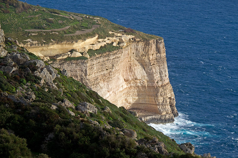
Dingli Cliffs in Malta
Deltas
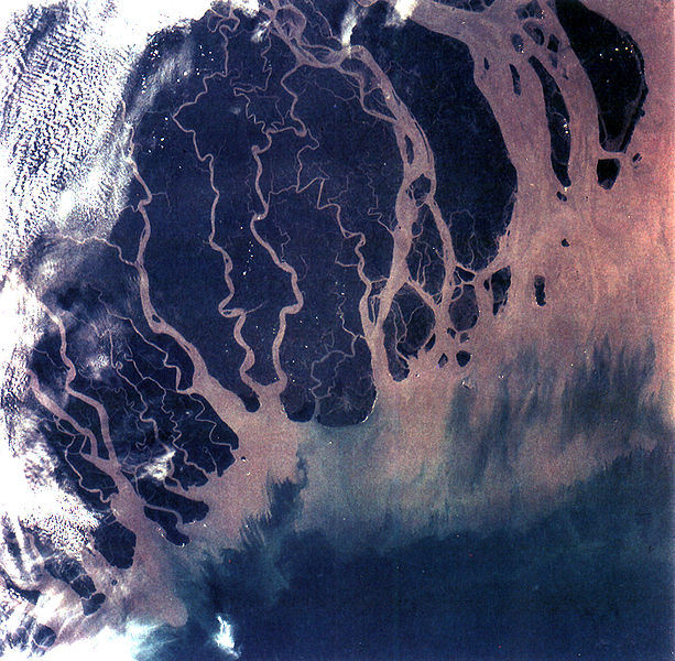
The Ganges Delta in India and Bangladesh is the largest delta in the world and it is also one of the most fertile regions in the world.
Deltas form when a river carrying sediment reaches a lake, sea, ocean, or reservoir.
Of course, the river must carry enough sediment to layer into deltas over time. The river’s velocity decreases rapidly, causing it to deposit the majority, if not all, of its load. This alluvium builds up to form the river delta. When the flow enters the standing water, it is no longer confined to its channel and expands in width. This flow expansion results in a decrease in the flow velocity, which diminishes the ability of the flow to transport sediment. As a result, sediment drops out of the flow and deposits. Over time, this single channel builds a deltaic lobe (such as the bird’s-foot of the Mississippi or Ural river deltas), pushing its mouth into the standing water. As the deltaic lobe advances, the gradient of the river channel becomes lower because the river channel is longer but has the same change in elevation.
Another way these distributary networks form is from deposition of mouth bars (mid-channel sand and/or gravel bars at the mouth of a river). When this mid-channel bar is deposited at the mouth of a river, the flow is routed around it. This results in additional deposition on the upstream end of the mouth-bar, which splits the river into two distributary channels. A good example of the result of this process is the Wax Lake Delta in Louisiana.
In both of these cases, depositional processes force redistribution of deposition from areas of high deposition to areas of low deposition. This results in the smoothing of the planform (or map-view) shape of the delta as the channels move across its surface and deposit sediment. Because the sediment is laid down in this fashion, the shape of these deltas approximates a fan. The more often the flow changes course, the shape develops as closer to an ideal fan, because more rapid changes in channel position results in more uniform deposition of sediment on the delta front.
Reefs
A reef is a bar of rock, sand, coral or similar material, lying beneath the surface of water. Reefs may be up to 261 feet (80 m) below the surface. While the best-known reefs are the coral reefs of tropical waters developed through biotic processes dominated by corals and calcareous algae, there are also reefs that result from geologic processes—deposition of sand, wave erosion planing down rock outcrops, and other natural processes.
Reefs are held up by a macroscopic skeletal framework. Coral reefs are an excellent example of this kind. Corals and calcareous algae grow on top of one another and form a three-dimensional framework that is modified in various ways by other organisms and inorganic processes.
Geologic reef structures
Ancient reefs buried within stratigraphic sections are of considerable interest to geologists because they provide paleo-environmental information about the location in Earth’s history. In addition, reef structures within a sequence of sedimentary rocks provide a discontinuity which may serve as a trap or conduit for fossil fuels or mineralizing fluids to form petroleum or ore deposits.
Corals, including some major extinct groups Rugosa and Tabulata, have been important reef builders through much of the Phanerozoic since the Ordovician Period. However, other organism groups, such as calcifying algae, especially members of the red algae Rhodophyta, and molluscs (especially the rudist bivalves during the Cretaceous Period) have created massive structures at various times. During the Cambrian Period, the conical or tubular skeletons of Archaeocyatha, an extinct group of uncertain affinities (possibly sponges), built reefs.
Other groups, such as the Bryozoa have been important interstitial organisms, living between the framework builders. The corals which build reefs today, the Scleractinia, arose after the Permian–Triassic extinction event that wiped out the earlier rugose corals (as well as many other groups), and became increasingly important reef builders throughout the Mesozoic Era. They may have arisen from a rugose coral ancestor. Rugose corals built their skeletons of calcite and have a different symmetry from that of the scleractinian corals, whose skeletons are aragonite. However, there are some unusual examples of well-preserved aragonitic rugose corals in the late Permian. In addition, calcite has been reported in the initial post-larval calcification in a few scleractinian corals. Nevertheless, scleractinian corals (which arose in the middle Triassic) may have arisen from a non-calcifying ancestor independent of the rugosan corals (which disappeared in the late Permian).
Barrier Islands
Barrier islands are coastal landforms and a type of dune system that are exceptionally flat or lumpy areas of sand that form by wave and tidal action parallel to the mainland coast. They usually occur in chains, consisting of anything from a few islands to more than a dozen. They are subject to change during storms and other action, but absorb energy and protect the coastlines and create areas of protected waters where wetlands may flourish. A barrier chain may extend uninterrupted for over a hundred kilometers, excepting the tidal inlets that separate the islands, the longest and widest being Padre Island of Texas. The length and width of barriers and overall morphology of barrier coasts are related to parameters including tidal range, wave energy, sediment supply, sea-level trends, and basement controls.

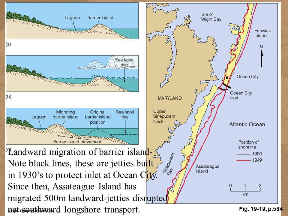
Image from Google Earth below shows Assateague barrier island on the eastern coast of US. This island migrated inland due to the persistent hurricane activity on the east coast.

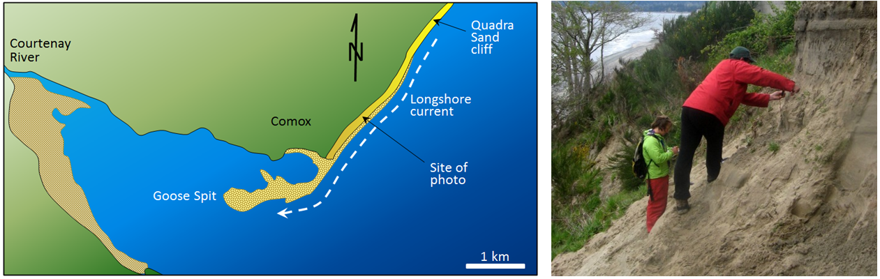
Sand Transport: Longshore Drift
Under the influence of waves sand moves parallel to shore forming littoral transport. In swash zone beach drift occurs when sand moves along with the zig zag wave pattern. Longshore drift is a long term transport of sand by longshore currents.
A good example of longshore drift is at Goose Spit at Comox on Vancouver Island (see image below). At this location, the longshore current typically flows toward the southwest, and the sand eroded from a 60 m high cliff of Pleistocene glaciofluvial Quadra Sand is pushed in that direction and then out into Comox Harbour.
 Source: https://opentextbc.ca/geology/chapter/17-3-landforms-of-coastal-deposition/ Another example of coastal forms created by longshore drift is Long Island, NY.
 Satellite images capture shoreline configuration and its characteristical features, see: https://earthobservatory.nasa.gov/images/90120/an-island-carved-by-water
