37 Stress, Strain and Structures
Enormous slabs of lithosphere move unevenly over the planet’s spherical surface, resulting in earthquakes and faults, structures produced by brittle deformations, close to the earth surface. Brittle deformations occur in “cold” bodies of rocks, similar to the breakage of bricks.
First, we will consider what can happen to rocks when they are exposed to stress deep under the earth surface. Because deep in earth interior rocks are warm and “soft”, they bend, producing so-called ductile deformations. Below are examples of folds, geologic features that show how rocks can be bended without being broken. This deformations are called ductile.
Folds near Doxaro village (ductile deformations) on Crete

Folds near Ag. Pavlos village (ductile deformations)

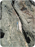
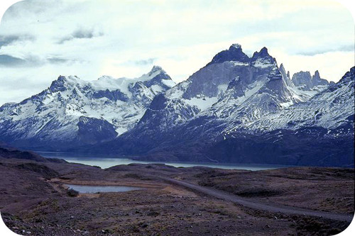
Famous Spili fault (brittle deformation)

Causes and Types of Stress
Stress is the force applied to an object. In geology, stress is the force per unit area that is placed on a rock.
Four types of stresses act on materials:
- A deeply buried rock is pushed down by the weight of all the material above it. Since the rock cannot move, it cannot deform. This is called confining or uniform stress. All rocks in the earth experience a uniform stress at all times. This uniform stress is called lithostatic pressure and it comes from the weight of rock above a given point in the earth. Because lithostatic pressure is a uniform stress, a change in lithostatic pressure does not cause fracturing and slippage along faults.
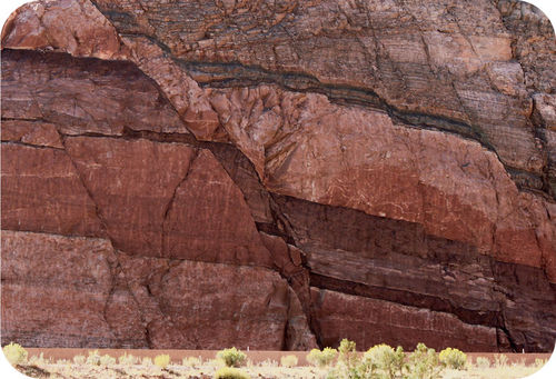
- Compression (shortening) squeezes rocks together, causing rocks to fold or fracture (break) (Figure 1). Compression is the most common stress at convergent plate boundaries.
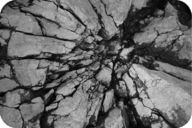
Figure 1. Stress caused these rocks to fracture.
3. Rocks that are pulled apart are under tension (stretching). Rocks under tension lengthen or break apart. Tension (stretching) is the major type of stress at divergent plate boundaries.
4. When forces are parallel but moving in opposite directions, the stress is called shear (Figure 2). Shear stress is the most common stress at transform plate boundaries or strike-slip faults. The shear forces are pushing in opposite ways.
Below is a diagram that shows three main type of stress and associated deformations: compression, tension and shearing.

Deformed rocks are common in geologically active areas such as plate boundaries.
Strain is any change in volume or shape due to the stress.
Ductile and Brittle Strain
Earth’s rocks are composed of a variety of minerals and exist in a variety of conditions. In different situations, rocks may act either as ductile materials that are able to undergo an extensive amount of ductile strain in response to stress, or as brittle materials, which will only undergo a little or no ductile strain before they fracture. The factors that determine whether a rock is ductile or brittle include:
- Composition—Some minerals, such as quartz, tend to be brittle and are thus more likely to break under stress. Other minerals, such as calcite, clay, and mica, tend to be ductile and can undergo much plastic deformation. In addition, the presence of water in rock tends to make it more ductile and less brittle.
- Temperature—Rocks become softer (more ductile) at higher temperature. Rocks at mantle and core temperatures are ductile and will not fracture under the stresses that occur deep within the earth. The crust, and to some extent the lithosphere, are cold enough to fracture if the stress is high enough.
- Lithostatic pressure—The deeper in the earth a rock is, the higher the lithostatic pressure it is subjected to. High lithostatic pressure reduces the possibility of fracture because the high pressure closes fractures before they can form or spread. The high lithostatic pressures of the earth’s sub-lithospheric mantle and solid inner core, along with the high temperatures, are why there are no earthquakes deep in the earth.
- Strain rate—The faster a rock is being strained, the greater its chance of fracturing. Even brittle rocks and minerals, such as quartz, or a layer of cold basalt at the earth’s surface, can undergo ductile deformation if the strain rate is slow enough.
Most earthquakes occur in the earth’s crust. A smaller number of earthquakes occur in the uppermost mantle (to about 700 km deep) where subduction is taking place. Rocks in the deeper parts of the earth do not undergo fracturing and do not produce earthquakes because the temperatures and pressures there are high enough to make all strain ductile. No earthquakes originate from below the the earth’s upper mantle.
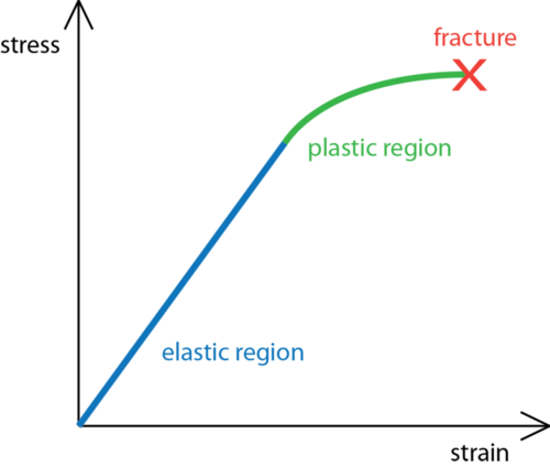
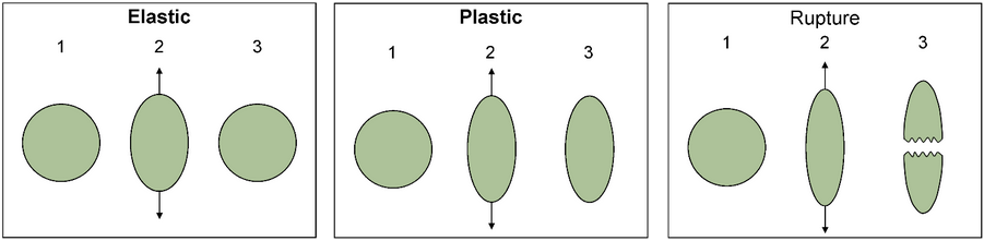
Rocks have three possible responses to increasing stress (illustrated in figure 3):
- Elastic strain is reversible. Rock that has undergone only elastic strain will go back to its original shape if the stress is released. This is rare occurs in nature.
- Plastic (ductile) strain is irreversible. A rock that has undergone plastic strain will remain deformed even if the stress stops. Ductile is another term for plastic. Very common in nature.
- Fracture is also called rupture. A rock that has ruptured has abruptly broken into distinct pieces. If the pieces are offset—shifted in opposite directions from each other—the fracture is a fault.
Under what conditions do you think a rock is more likely to fracture? Is it more likely to break deep within Earth’s crust or at the surface? What if the stress applied is sharp rather than gradual?
- At the Earth’s surface, rocks usually break quite quickly, but deeper in the crust, where temperatures and pressures are higher, rocks are more likely to deform plastically.
- Sudden stress, such as a hit with a hammer, is more likely to make a rock break. Stress applied over time often leads to plastic deformation
Demonstration of plastic state in rocks (starts at 5:30 – 7:43): https://www.youtube.com/watch?v=Dd6iR9FbDbg
Demonstration of elastic state and fracturing in rocks (starts at 38:12 – 40:15): https://www.youtube.com/watch?v=Dd6iR9FbDbg
Geologic Structures
Sedimentary rocks are important for deciphering the geologic history of a region because they follow certain rules.
- Sedimentary rocks are formed with the oldest layers on the bottom and the youngest on top. If this is not the case, then we know that rocks experienced some kind of deformation.
- Sediments are deposited horizontally, so sedimentary rock layers are originally horizontal. Sedimentary rock layers that are not horizontal are deformed.
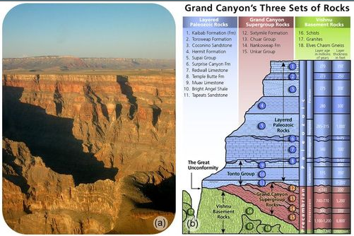
You can trace the deformation a rock has experienced by seeing how it differs from its original horizontal, oldest-on-bottom position, for example Grand Canyon structure (figure 4a,b).
Can geologic principle of superposition be violated by deformations?
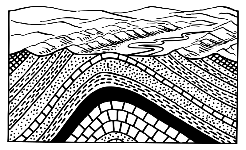
On the figure below we see how compressional forces fold horizontal rock layers: (1) original horizontal formation (2), compression starts, eventually creating a symmetrical fold (3); with continuing compression from the left side and decreasing compression from the right side, the left side inclines toward the right, creating asymmetrical fold (4) and eventually the fold leans more toward the right side (5) creating conditions for the thrust fault

On the figure below it is clear how older rocks (green layer) can be found on the top of the younger one (orange layer).

Folds: plastic deformations
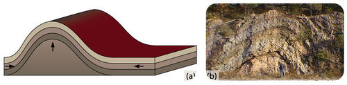
Rocks deforming plastically under compressive stresses crumple into folds (figure 5). They do not return to their original shape. If the rocks experience more stress, they may undergo more folding or even fracture.
The most basic types of folds are anticlines and synclines. Imagine a rug, the sides of which have been pushed toward each other forming ridges and valleys – the ridges are “up” folds and the valleys are “down” folds. In terms of geologic structures, the up folds are called anticlines and the down folds are called synclines. Anticlines and synclines form in sections of the crust that are undergoing compression, places where the crust is being pushed together.
In block diagrams like those shown below, the top of the block is the horizontal surface of the earth, the map view. It is flat, and it is eroded. The other two visible sides of the box are cross-sections, vertical slices through the crust. The colored layers represent stratified geologic formations that were originally horizontal, such as sedimentary beds or lava flows. Use the block diagrams to visualize the three-dimensional shapes of the geologic structures. Keep in mind that erosion has stripped away the upper parts of these structures so that map view reveals the interior of these structures.
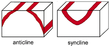 In map view, an anticline appears as parallel beds of the same rock type that dip away from the center of the fold. In an anticline, the oldest beds, the ones that were originally underneath the other beds, are at the center, along the axis of the fold. The axis is an imaginary line that marks the center of the fold on the map.
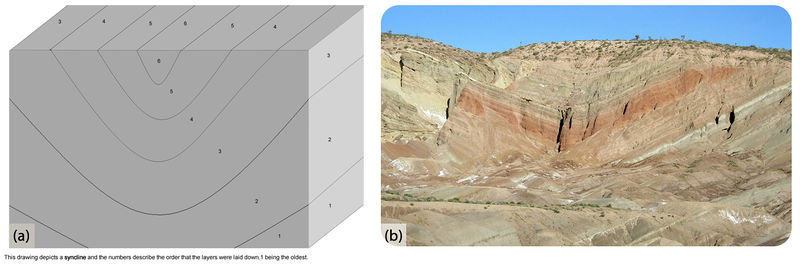
In map view, a syncline appears as a set of parallel beds that dip toward the center. In a syncline the youngest beds, the ones that were originally on top of the rest of the beds, are at the center, along the axis of the fold.
Three types of folds:
- Monocline: A monocline is a simple bend in the rock layers so that they are no longer horizontal (see figure 6 for an example).
- Anticline: An anticline is a fold that arches upward (Figure 7, 8). The rocks dip away from the center of the fold. The oldest rocks are at the center of an anticline and the youngest are draped over them.
Demonstration of mapping anticline using drilling (starts at 26:49 – 28:16): https://www.youtube.com/watch?v=Dd6iR9FbDbg
Syncline: A syncline is a fold that bends downward. The youngest rocks are at the center and the oldest are at the outside (figure 8). On a geologic map, synclines are recognized by a sequence of rock layers that grow progressively younger, followed by the youngest layer at the fold’s center or hinge, and by a reverse sequence of the same rock layers on the opposite side of the hinge.
Anatomy of a Fold:
https://viva.pressbooks.pub/physicalgeologylab/chapter/folds/
An example: 3D Syncline: Stackpole Syncline, Pembrokeshire, SW Wales:
https://sketchfab.com/3d-models/stackpole-syncline-9e4466b58d844c2bab791009f0766706
Anticlines are often flanked by synclines (Figure 9) although faulting can complicate and obscure the relationship between the two.
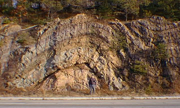
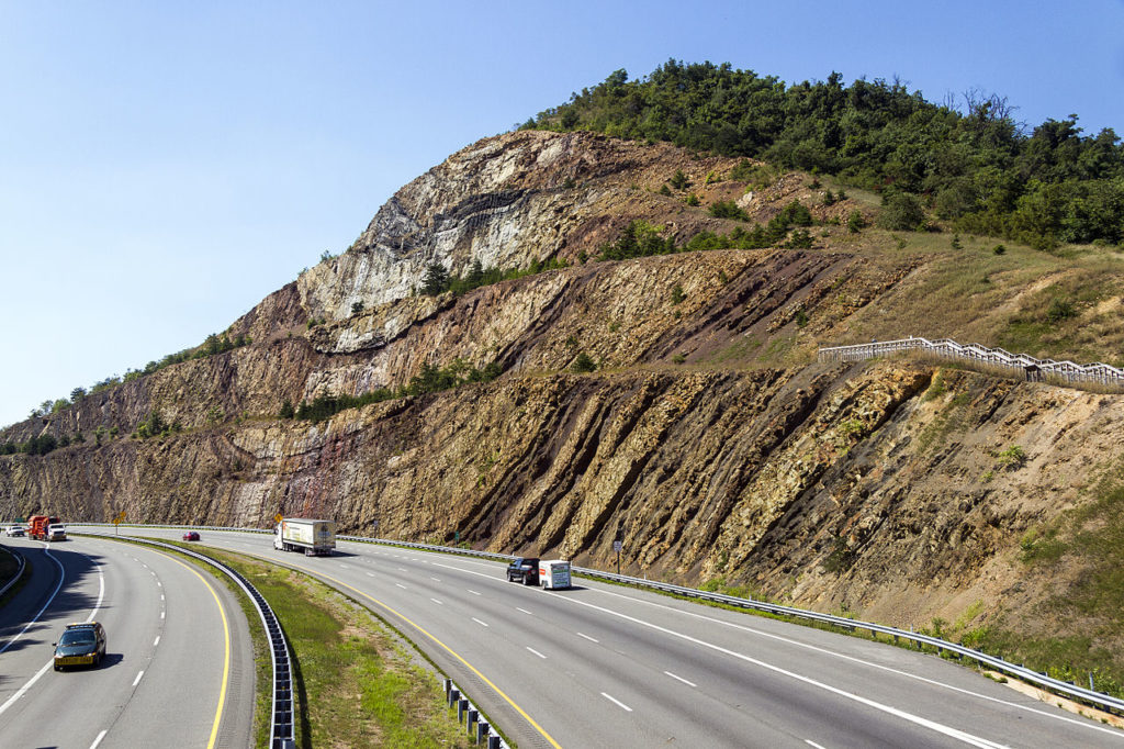 Figure 10. The Sideling Hill syncline as exposed in the Interstate 68 roadcut to the west of Hancock, Maryland, USA
Ductile rocks behave plastically and become folded in response to stress. Even in the shallow crust where rocks are cool and relatively brittle, folding can occur if the stress is slow and steady and gives the rock enough time to gradually bend. If the stress is applied too quickly, rocks in the shallow crust will behave as brittle solids and break. Deeper in the crust, where the rocks are more ductile, folding happens more readily, even when the stress and strain occurs rapidly.
Domes and Basins
When rocks arch upward to form a circular structure, that structure is called a dome. It plunges in all directions to form a circular or elongate structure. Domes are generally formed from one main deformation event, e.g. from underlying magmatic intrusions or movement of upwardly mobile, mechanically ductile material such as rock salt (salt dome) and shale (shale diapir).
A basin is similar to a syncline, but instead of an axis it has a single point at the center. The strata all dip toward the center point and the youngest rock is at the center (Figure 11). In map view, the strata form concentric circles – a bull’s eye pattern – around the center point.
Economic significance of geologic structures
Doubly plunging or faulted anticlines, culminations, and structural domes are favored locations for oil and natural gas drilling; the low density of petroleum causes it to buoyantly migrate upward to the highest parts of the fold (Figure 12), until stopped by a low-permeability barrier such as an impermeable stratum or fault zone. Examples of low-permeability seals that contain the hydrocarbons, oil and gas, in the ground include shale, limestone, sandstone, and even salt domes. The actual type of stratum does not matter as long as it has low permeability.
Figure 12. Structural trap: anticlinal fold. Red color marks area that can trap hydrocarbons (oil, gas).
Oil and Gas Formation:
Faults and Joints: Brittle deformations
A rock under enough stress will fracture. If there is no movement on either side of a fracture, the fracture is called a joint, as shown in (Figure 13).
Demonstration of faulting (starts at 11:59 –19:12): https://www.youtube.com/watch?v=Dd6iR9FbDbg
If the blocks of rock on one or both sides of a fracture move, the fracture is called a fault (Figure 14). Sudden motions along faults cause rocks to break and move suddenly. The energy released is an earthquake.
There are two main types of faults. In normal faults, the hanging wall drops down relative to the footwall. In reverse faults, the footwall drops down relative to the hanging wall (Fig. 15).
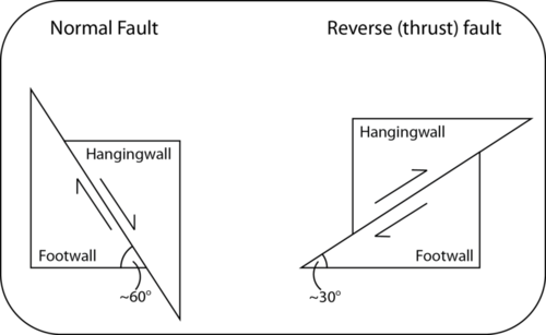
A thrust fault is a type of reverse fault in which the fault plane angle is at low angle and/or nearly horizontal.
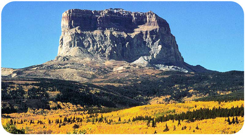
Rocks can slip many miles along thrust faults (Figure 16).
A strike-slip (also known as transform) fault is another kind of fault that results from shear stresses (figure 17).
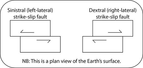
California’s San Andreas Fault is the world’s most famous strike-slip fault. It is a right-lateral strike slip fault (figure 17).
Demonstration of San Andreas fault
Stress and Common Fault Types
The following correlations can be made between types of stress in the earth, and the type of fault that is likely to result:
- Tension leads to normal faults.
- Compression leads to reverse or thrust faults.
- Horizontal shear leads to strike-slip faults.
Correlations between type of stress and type of fault can have exceptions. For example, zones of horizontal stress will likely have strike-slip faults as the predominant fault type. However there may be active normal and thrust faults in such zones as well, particularly where there are bends or gaps in the major strike-slip faults.
Anatomy of a Fault (click on Faults or …Continue reading)
Stress and Mountain Building
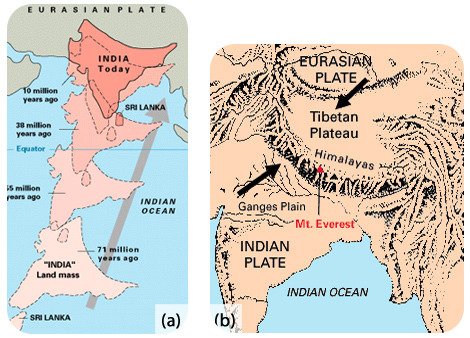
Two converging continental plates smash upwards to create mountain ranges (figure 19). Stresses from this uplift cause folds, reverse faults, and thrust faults, which allow the crust to rise upwards.
Subduction of oceanic lithosphere at convergent plate boundaries also builds mountain ranges (Figure 20).
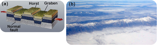
When tensional stresses pull crust apart, it breaks into blocks that slide up and drop down along normal faults.
The result is alternating mountains and valleys, known as a basin-and-range (Figure 21).
Lesson Summary
- Stress is the force applied to a rock and may cause deformation. The three main types of stress are typical of the three types of plate boundaries: compression at convergent boundaries, tension at divergent boundaries, and shear at transform boundaries.
- Where rocks deform plastically, they form folds. Brittle deformations result in fractures and faults.
- The world’s largest mountains grow at convergent plate boundaries, primarily by thrust faulting and folding.
