63 Drainage Basins, Longitudinal Profiles, Tectonics
A stream is a body of flowing surface water of any size, ranging from a tiny trickle to a mighty river. The area from which the water flows down to form a stream is known as its drainage basin. Sometimes it is also called watershed or watershed basin. All of the precipitation (rain or snow) that falls within a drainage basin eventually flows into its stream, unless some of that water is able to cross into an adjacent drainage basin via groundwater flow. An example of a drainage basin is shown in Figure 1.Stream network within a specific drainage basin is called a drainage network.
The drainage area of a stream encompasses all the land from which surface runoff flows into that stream. Boundaries between stream drainage areas are called drainage divides. Below is computer based rendering of the digital elevation model(dark brown colors – high elevations, light-green – low elevations) and watershed basin (in green).

See example of the Lake Champlain Basin Atlas Watershed Areas and Tributaries:
http://atlas.lcbp.org/nature-environment/watersheds-and-tributaries/
Drainage Basin Patterns
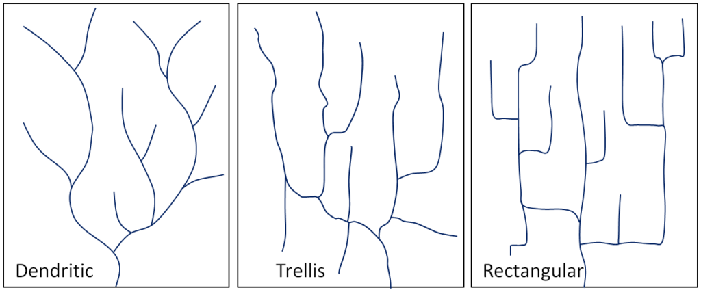
The pattern of tributaries within a drainage basin depends largely on the type of rock beneath, and on structures within that rock (folds, fractures, faults, etc.). The three main types of drainage patterns are illustrated in Figure 3. Dendritic patterns, which are by far the most common, develop in areas where the rock (or unconsolidated material) beneath the stream has no particular fabric or structure and can be eroded equally easily in all directions. Examples would be granite, gneiss, volcanic rock, and sedimentary rock that has not been folded. Most areas of British Columbia have dendritic patterns, as do most areas of the prairies and the Canadian Shield. Trellis drainage patterns typically develop where sedimentary rocks have been folded or tilted and then eroded to varying degrees depending on their strength. The Rocky Mountains of B.C. and Alberta are a good example of this, and many of the drainage systems within the Rockies have trellis patterns. Rectangular patterns develop in areas that have very little topography and a system of bedding planes, fractures, or faults that form a rectangular network. Rectangular drainage patterns are rare in Canada.
Stream Longitudinal Profiles
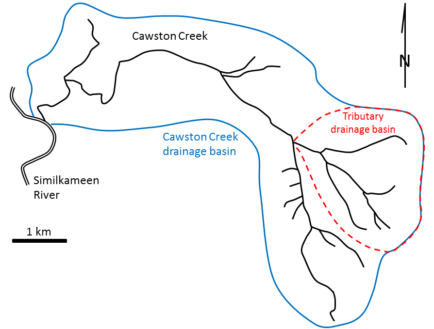
Longitudinal profiles are plots of the elevation vs distance from the stream mouth to the upper reaches within watershed basin. They help to establish relationship between slope steepness and distance from the upper to lower reaches. Slope or gradient can be measured in degree or percentage (rise over run). Below is an example of stream longitudinal profile for Cawston Creek.
Cawston Creek is a typical small drainage basin (approximately 25 km2) within a very steep glaciated valley. As shown in Figure 2, the upper and middle parts of the creek have steep gradients (averaging about 200 m/km but ranging from 100 to 350 m/km), and the lower part, within the valley of the Similkameen River, is relatively flat (<5 m/km). The shape of the valley has been controlled first by tectonic uplift (related to plate convergence), then by pre-glacial stream erosion and mass wasting, then by several episodes of glacial erosion, and finally by post-glacial stream erosion. The lowest elevation of Cawston Creek (275 m at the Similkameen River) is its base level. Cawston Creek cannot erode below that level unless the Similkameen River erodes deeper into its flood plain (the area that is inundated during a flood).
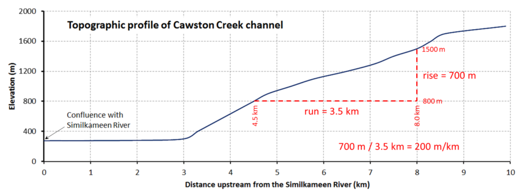
Cawston Creek profiles shows many levels of gradient along its profile. For example, there are different gradients between 8.4 and 10 km, 3 and 5 km. This means that surface erosion has not yet leveled or graded Cawston Creek; therefore it is called ungraded stream. This stream is “immature” and has not experience intensive erosion.
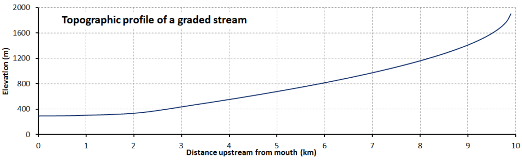
Over geological time, a stream will erode its drainage basin into a smooth profile similar to that shown in Figure 5. If we compare this with an ungraded stream like Cawston Creek (Figure 1), we can see that graded streams are steepest in their headwaters and their gradient gradually decreases toward their mouths. They are “mature” because they experienced intensive erosion. Ungraded streams have steep sections at various points, and typically have rapids and waterfalls at numerous locations along their lengths.
Influence of Tectonic Movements on Streams
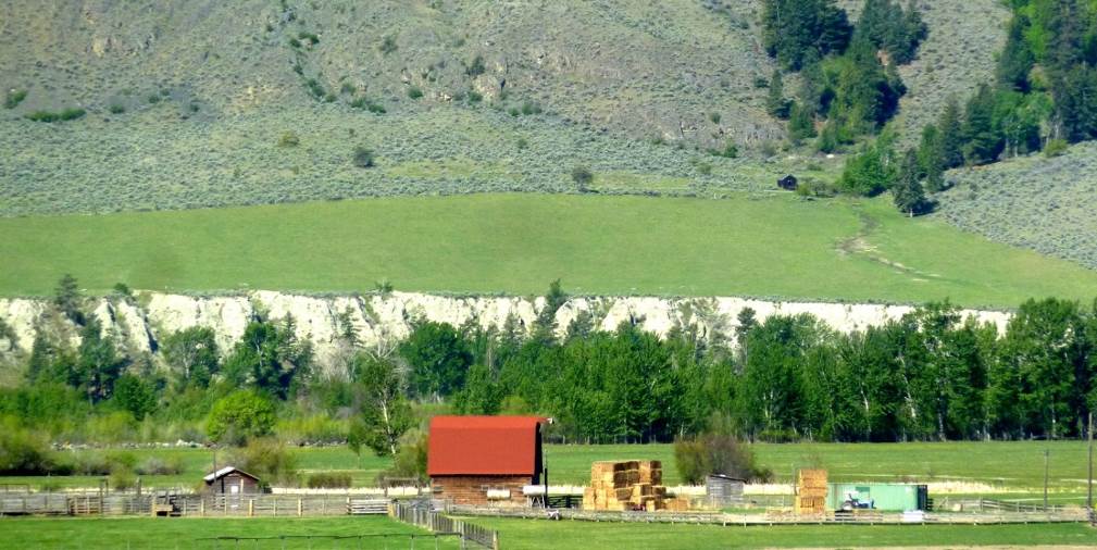 Figure 6. An example of a change in the base level of a small stream that flows into the Similkameen river near Keremeos. The previous base level was near the top of the sandy bank. The current base level is the river.
A graded stream can become ungraded if there is renewed tectonic uplift, or if there is a change in the base level, either because of tectonic uplift or some other reason. As stated earlier, the base level of Cawston Creek is defined by the level of the Similkameen River, but this can change, and has done so in the past. Figure 6 shows the valley of the Similkameen River in the Keremeos area. The river channel is just beyond the row of trees. The green field in the distance is underlain by material eroded from the hills behind and deposited by a small creek (not Cawston Creek) adjacent to the Similkameen River when its level was higher than it is now. Sometime in the past several centuries, the Similkameen River eroded down through these deposits (forming the steep bank on the other side of the river), and the base level of the small creek was lowered by about 10 m. Over the next few centuries, this creek will seek to become graded again by eroding down through its own alluvial fan.
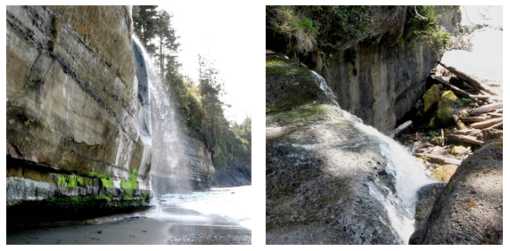
Another example of a change in base level can be seen along the Juan de Fuca Trail on southwestern Vancouver Island. As shown in Figure 7, many of the small streams along this part of the coast flow into the ocean as waterfalls. It is evident that the land in this area has risen by about 5 m in the past few thousand years, probably in response to deglaciation. The streams that used to flow directly into the ocean now have a lot of down-cutting to do to become regraded.
The ocean is the ultimate base level, but lakes and other rivers act as base levels for many smaller streams.
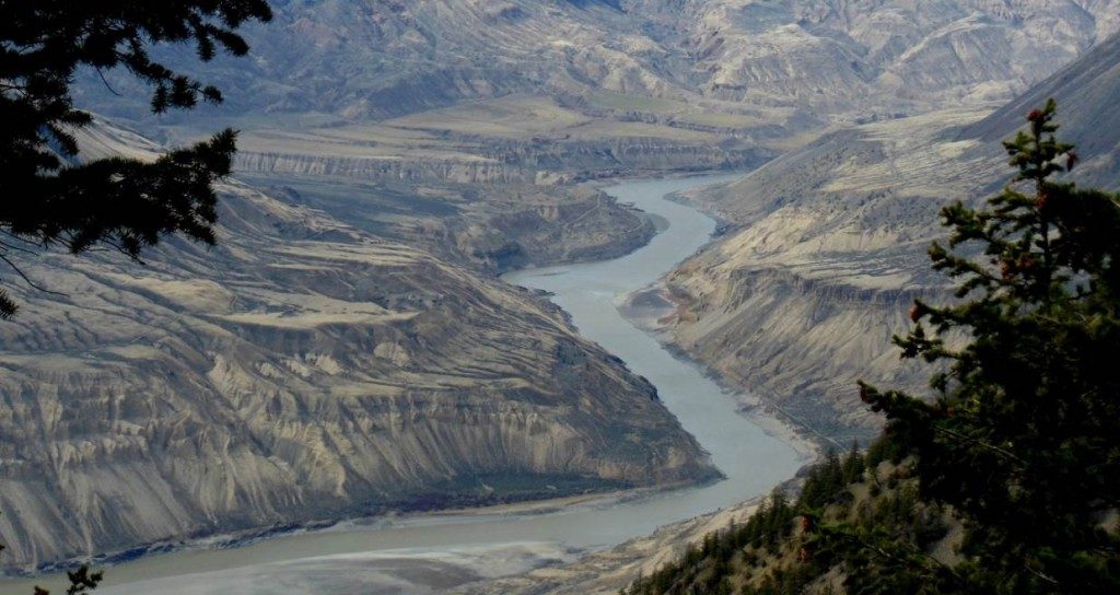
Figure 9. Terraces on the Fraser River at High Bar. [Marie Betcher photo, used with permission]
Sediments accumulate within the flood plain of a stream, and then, if the base level changes, or if there is less sediment to deposit, the stream may cut down through those existing sediments to form terraces. A terrace on the Similkameen River is shown in Figure 6 and some on the Fraser River are shown in Figure 9. The Fraser River photo shows at least two levels of terraces.
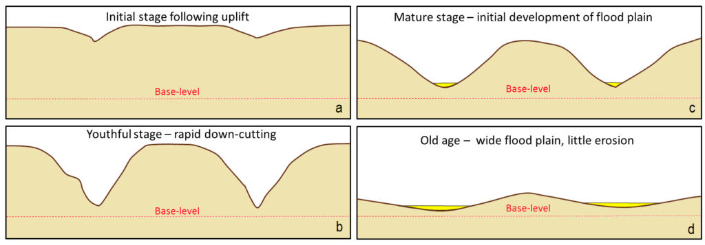
In the late nineteenth century, American geologist William Davis proposed that streams and the surrounding terrain develop in a cycle of erosion (Figure 10). Following tectonic uplift, streams erode quickly, developing deep V-shaped valleys that tend to follow relatively straight paths. Gradients are high, and profiles are ungraded. Rapids and waterfalls are common. During the mature stage, streams erode wider valleys and start to deposit thick sediment layers. Gradients are slowly reduced and grading increases. In old age, streams are surrounded by rolling hills, and they occupy wide sediment-filled valleys. Meandering patterns are common.