6 Introduction to dating methods and the role of stratigraphy in understanding geologic history
Time is a philosophical category: no end and no beginning, or
“… we find no vestige of a beginning – no prospect of an end.” (James Hutton).
This makes geology partially philosophical science since we never know the extent and real dimension of time. In this case our own place in time is just a flick among series of evolutionary events. However, as humans we are always ready to place ourselves as central or influential figures with our own time scale that is a miniscule, comparing to the time of universe. We see events, especially natural hazards, as if they occur suddenly, in our own tiny time span, but unfortunately we never learn.
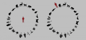
Below is a humorous illustration of this “anthropocentric” behavior. It leads us on focusing on our own time scale, with disregard to surrounding world.
Geologic time (as we formalize it) covers the whole sweep of earth’s history, from how and when the earth first formed, to everything that has happened on, in, and to the planet since then, right up to now.
Geologists analyze geologic time in two different ways: in terms of relative geologic age, and in terms of absolute (or numeric) geologic age.
The combination of these two types of geologic ages makes a complete record of earth’s geologic history in terms of the order of events and in terms of how many years ago each event occurred.
Relative geologic age refers to the order in which geologic events occurred. It is studied by stratigraphy, science of strata, or geologic layers.
Relative geologic age is established by stratigraphic laws, based on the order in which layers of sediment are stacked, with the younger layer originally on top. By using the principles of relative geologic age, the sequence of geologic events — what happened first, what happened next, what happened last — can be established.
Absolute geologic age refers to how long ago a geologic event occurred or a rock formed, in numeric terms; for example, “these rocks are 65.5 million years old”. It is studied mainly by geochronology based on geochemistry and/or physics.
Rocks and minerals can have their absolute age directly measured by analyzing the ratios of certain isotopes they contain. The method is based on simple counting of the amount of isotopes in the rock. Because of advances in geochemical methods we need now very small amount of rock sample comparing to what was required 80 years ago.
The units commonly used for geologic age are mega-annum (Ma) for millions of years, giga-annum (Ga) for billions of years, and kiloannum (ka) ka for thousands of years.
Because these units are used according to the rules of the metric system, the M in Ma and the G in Ga must be capitalized, and the k in ka must not be capitalized.
Much of the most detailed and precise information that geologists have gleaned of earth’s history comes from a branch of geology known as stratigraphy.
Stratigraphy is the study of rock layers and reconstruction of the original sequence in which they were deposited. Stratigraphy studies stratified rocks, – layered rocks, and establishes their age sequence based on principles of relative geologic age, and reconstructs, from the evidence in the rocks and from their field relations as depicted on maps and cross-sections, the geologic history that they represent.
 Crete (Greece), a stratigraphic sequence of sedimentary rocks
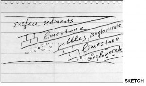
Geologic sketch of the layers above
Stratigraphy became a formal science due to the work of Nicolas Steno in the 17th century.

Steno made careful geologic observations and illustrations. He established a basic set of principles for interpreting sedimentary strata. Geologists still use Steno’s principles, with some refinements and additions. They are summarized as the principles of relative geologic age. The stratigraphy of an area provides the basis for putting together its geologic history.
Important fact to keep in mind: strata represent either rocks or compressed/solidified sediments in the shape of layers, yes, like a cake!

It takes time to convert loose sediment into rocks or tightly compress sediment.
Therefore, logically, any inclusion in the rock will be OLDER than the strata where it is located. This is the biggest geologic secret! Do not tell anybody outside of our class!

An example is a sediment layer with inclusions such as pebbles or dinosaur bones. If you replay the origin of strata then the first thing to appear will be pebble or dinosaur have to die to produce a bone. Correct? This is time step 1. Then pebbles and bones get cemented to form a layer. This is a time step 2. So, which time step is older? I am sure you get the right answer.
The details of a region’s stratigraphic story are revealed by:
- What exactly is in each stratum (layer)– the types of rocks and minerals, the sedimentary structure, and the fossils. This reveals what was happening at the time the layer of sediment was being deposited in terms of geological activity, water, climate, and living things. For example, finding shark teeth in a strata would mean that teeth (and sharks who have them) ended up in a strata when it was not a rock but loose material, most likely under the water since sharks swim! This makes shark tooth older than the rock and environment of sediment formation marine or oceanic.
- The sequence of strata — which layer is on a top of which. This allows the story to be told sequentially as a series of changes, some gradual, some abrupt. For example, thick layers of volcanic ash on the top of lake sediments would mean that lake was buried under the ash and ceased to exist. We say that volcanic ash is younger and lake sediments are older.
- The structural arrangement of the layers — how the strata are affected by folds, faults, or igneous intrusions.


Fold Fault Intrusions
(Source: wikipedia; https://www.sciencedirect.com/topics/earth-and-planetary-sciences/intrusion)
This gives information on processes such as tectonic plate collisions, terrane accretion, and volcanic activity. For example. if we see wave-like strata (fold), we need to explain the mechanism of such deformation because we know that normally all strata are deposited horizontal. Observed folds also mean that they are older than the strata itself, i.e. deformations occurred after strata were formed.
Below is a photo of geologic layers deposited differently: top layer is horizontal and the bottom layer is not; it dips 45 degrees. You also see the sharp boundary between these two layers. Imagine how this could happen????? In stratigraphy we call this “angular unconformity” (see few paragraphs below).
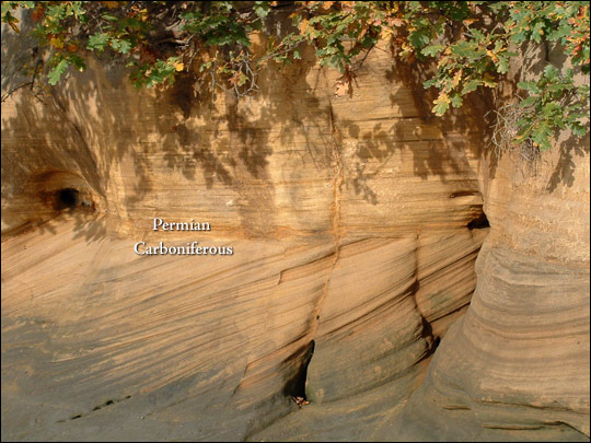
Source: The boundary between the Permian Yellow Sands Formation (above), and the Carboniferous Pennine Upper Coal Measures (below)
is exposed along the banks of the River Wear, roughly 500 kilometers north of Bath.
(Photograph ©2003 George Plemper. Image interpretation by John H Powell, British Geological Survey.)
https://earthobservatory.nasa.gov/features/WilliamSmith
Ask yourself how the things that are happening in the world today might end up being recorded in the sediments that are now or soon will be deposited.
How would today’s sediments appear to a geologist millions of years in the future examining outcrops of sedimentary rock that originated in our time?
What would the geologist be able to deduce about the world we live in, based on what was left in the strata?
Stratigraphic Laws
1. Law of Original Horizontality
The most basic foundation of stratigraphy is that all sedimentary layers are predominantly formed horizontally.
2. Law of Superposition
Younger layer is always on the top of the older layer.
3. Law (or principles) of Unconformities
James Hutton of Scotland, the same man who developed the modern concept of the rock cycle as a reflection of the endlessly dynamic and constantly changing earth, advanced the theory of unconformities through observations.
This is a third stratigraphic principle or law known as “principle of unconformities”, i.e. irregularity in strata caused by deformations or erosion events. There are many types of unconformities.
General term unconformity refers to three types:
- Disconformity, i.e. a buried erosional surface or non-depositional surface, a contact between the rocks below and the layer of stratified rock above that is missing a significantly large interval of geologic time. This can happen due to the flood event, geologic fault, erosion by sea waves, rain, wind.
- Angular unconformity: when one layer is horizontal and another one is not.
- Nonconformity: when two adjacent layers consist of two different types of rocks, usually igneous and sedimentary OR igneous and metamorphic.
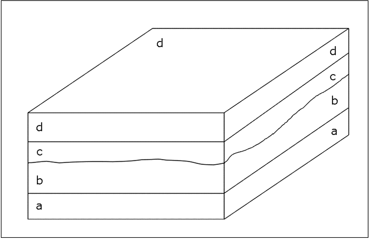
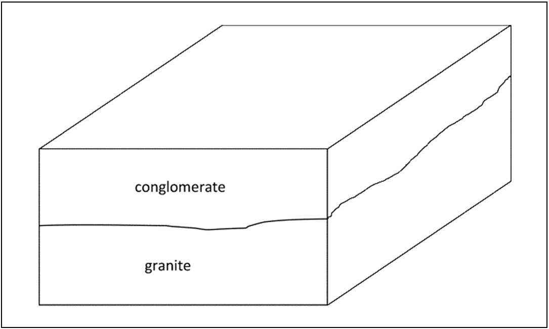
Three types of unconformities:
1. angular unconformity (see below). The uneven boundary line between horizontal and tilted layers is erosional surface. See Permian Yellow Sands Formation photo above. It illustrates this principle.
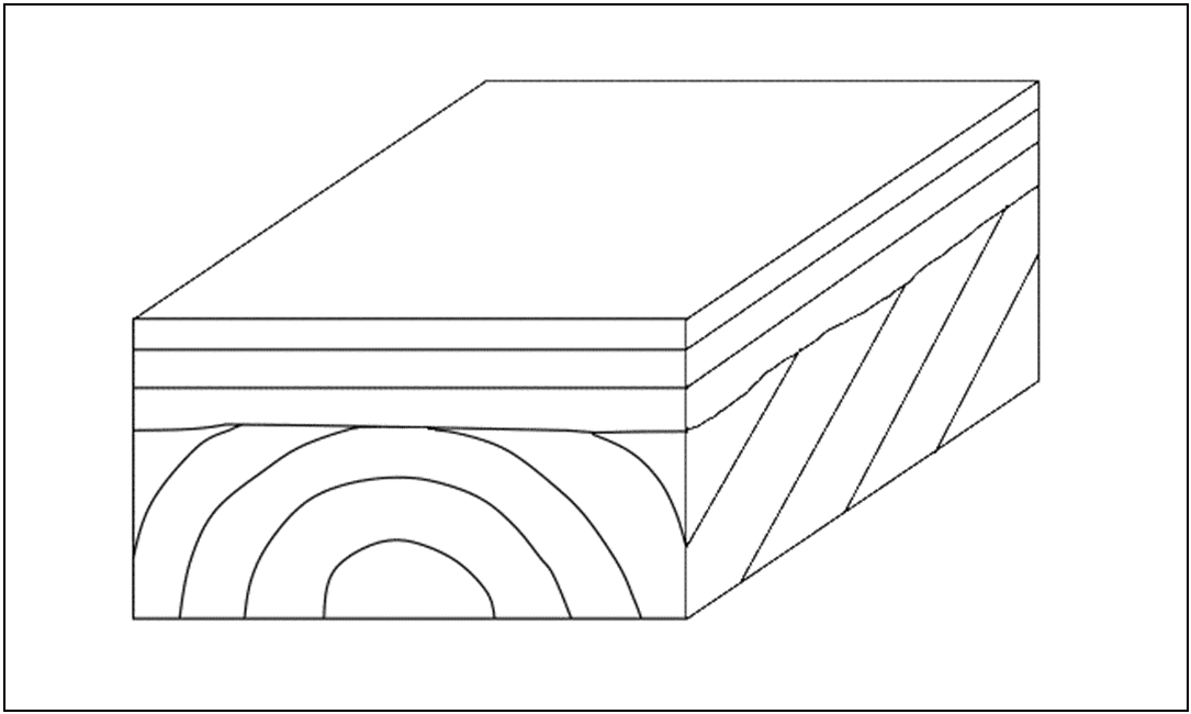 2. disconformity (one layer is missing and instead of it we see erosional surface, see curvy line between layers b and c).
 3. nonconformity (contact between intrusive bodies and surrounding rocks; in this example granite (intrusive igneous rock) and conglomerate (sedimentary rock).
 James Hutton spend a lot of time observing rock formation in his neighborhood and these observations lead him to various questions that he wanted to answer (see previous Lecture on scientific method). One of the famous locations that he often visited was Siccar Point. Photo below shows its contemporary view with almost flat eroded red sandstone outcrop above conglomerate and vertical ribs of greywacke (specific kind of sandstone, associated with volcanism), a feature sketched in 1788 by Sir James Hall. This is an example of angular unconformity, i.e. layers of rocks are under different angles to each other.
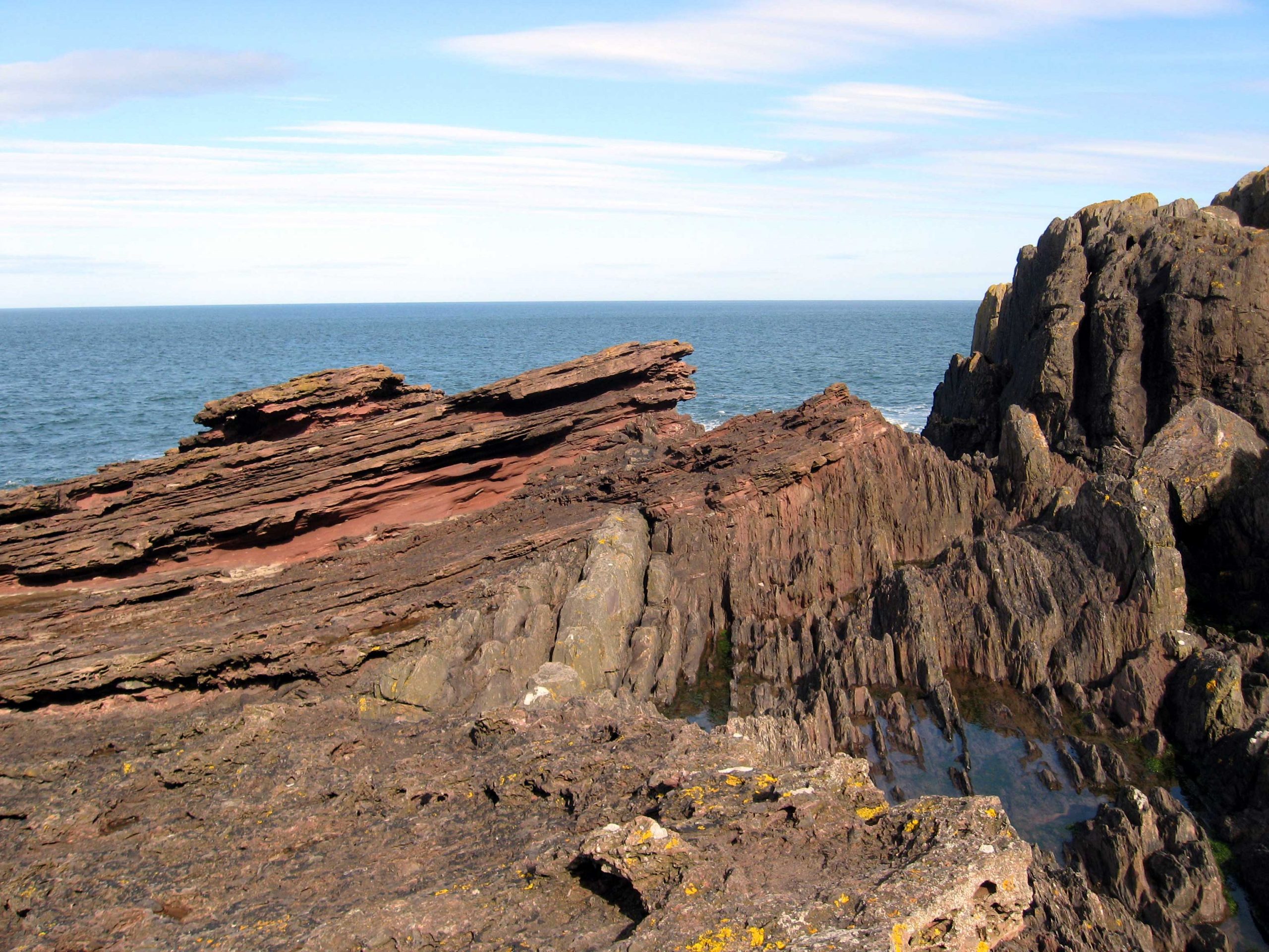
Siccar Point, Scotland. Photo was taken by Dave Souza from Wikipedia.
Class activity: How can we learn Earth history from this strange outcrop? Let’s try to do this together, taking as a basis Nicolas Steno principle of original horizontality.
For more comprehensive answer check explanation in Edinburgh Geological Society publication (see here: https://edinburghgeolsoc.org/downloads/Siccar-Point-LBGC-leaflet.pdf)
4. Law (or principle) of cross-cutting relationship
James Hutton and other geologists at that time also postulated the fourth stratigraphic principle: cross-cutting relationship. This principle was developed after observations of intrusions (molten magma bodies) in sedimentary rocks and realizing that they are younger than surrounding rocks.
Below are two illustrations from National Park Service web site (https://www.nps.gov/articles/geologic-principles-cross-cutting-relationships.htm) demonstrating cross-cutting relationship.
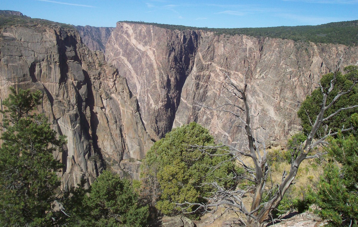 Pegmatite dikes exposed in Painted Wall cliff face. The light colored dikes are younger than the dark rock. Black Canyon of the Gunnison National Park, Colorado.
 A diabase dike at Hance Rapid on the Colorado River cross-cuts the Hakatai Shale. Grand Canyon National Park, Arizona.
Class Activity: sequence of events and their relative age
See diagram with geologic structure of the hypothetical region and place layers according to their relative time origin (older, younger), maybe not the whole list, but just a few example:
http://profharwood.x10host.com/GEOL101/Labs/Dating/index.htm
In the early 1800s, soon after James Hutton died, William Smith in England made the scientific case for what came to be called the principle or law of faunal succession (see: https://en.wikipedia.org/wiki/Principle_of_faunal_succession). The key to this principle is that during a specific geologic time, only certain types of organisms existed, so if fossils of those organisms are found in a layer of rock, the rock is of that geologic age, the age when those organisms were species that lived on earth.
This principle was based on applying other methods of determining which rocks are older and which rocks are younger, which verifies that there is indeed a faunal (or fossil, if you prefer) succession that occurs in the same order in the rock layers everywhere on earth.
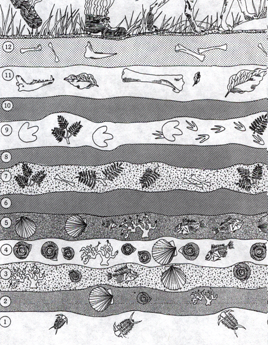 Schematic view of stratigraphic layers shows various fossils, forming what is called “faunal succession”;
Schematic view below shows use of fossils in faunal succession to discover connections between geologic layers; this helped in study Earth history and evolution and also in mapping geologic time.
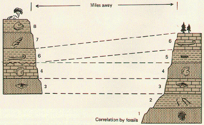
Illustration is courtesy of The Changing Earth – Introduction to Geology (2nd ed.), by Mears, Jr., D. Van Nostrand Co., 1977
Charles Lyell adapted Hutton’s theory of uniformitarianism in his book “Principles of Geology”, the first ever published geology textbook. Lyell wrote: “Hutton labored to give fixed principles to geology, as Newton had succeeded in doing to astronomy”. According to Hutton “The ruins of an older world are visible in the present structure of our planet, and the strata which now compose our continents have been once beneath the sea, and were formed out of the waste of pre-existing continents. The same forces are still destroying, by chemical decomposition or mechanical violence, even the hardest rocks, and transporting the materials to the sea, where they are spread out, and form strata analogous to to those of more ancient date.” (“Principles of Geology”, v.1, p. 61, The University of Chicago Press).
The idea of uniformitarianism is that the laws and principles that nature follows in today’s world, such as gravity, also applied in the geologic past; in other words, “the present is the key to the past.”
Lyell was a significant scientific presence through much of the time of Victorian England in the 1800s. He had a large influence on the development and spread of the practice of geology as a science, partly through his textbook, The Principles of Geology. This was not only the first complete geology textbook published in English, it was by far the most widely used textbook for decades, through several revised editions. A copy of The Principles of Geology that Charles Darwin read had a major influence in his thinking as he traveled around the world collecting samples, and Darwin consulted with Lyell at key stages during the time he developed and published his theory of evolution of species by natural selection.
Below you see two photos: one is contemporary beach (in NJ, 2020) and another is Dakota Formation (Late Cretaceous, approx 100,000,000 years), near Denver (Colorado). Both are courtesy of Dr. Bryce M. Hand, Emeritus Professor of Geology, Syracuse University. These images show that contemprary processes that formed ripples on the beach can be used to explain similar beach forms 100,000,000 years ago.

The idea of uniformitarianism is commonly misinterpreted in two different ways.
The first incorrect interpretation is that it states that only slow changes occur on earth.
The second misinterpretation is that it states that cataclysmic events cannot have happened in the past.
Uniformitarianism does not require that all geological processes are slow. Some are abrupt, such as an explosive volcanic eruption, an earthquake, or a landslide. It is true, and needs to be kept in mind to understand the earth geologically, that many geologic processes are slow, accumulating into larger effects over the course of geologic time. For example, we now know that continents move across the face of the earth a few centimeters a year as part of tectonic plates. A few centimeters a year, about the rate your fingernails grow, may not seem like much but, as millions of years of geologic time unfold, it adds up to thousands of kilometers . Fast or slow, abrupt or taking millions of years, uniformitarianism includes natural processes of all different rates, from abrupt and cataclysmic to barely detectable and very slow.
In addition, uniformitarianism does not rule out the possibility that larger cataclysms could have happened in the geologic past than humans have witnessed in the modern world. For example, the evidence is strong that a catastrophic meteorite impact at the end of the Cretaceous period was the cause, or precipitating factor, of a major mass extinction, when the last of the dinosaurs passed from existence on earth, along with many other species. This is consistent with uniformitarianism. The key is that the meteorite and its effects on the ocean, the atmosphere, and on life happened according to the laws and behaviors of physics, chemistry, and biology, the same laws and behaviors we can observe in nature and verify by experimentation today.
Geologic principles discussed above helped understanding the structure of the lithosphere, specifically continental crust in many different ways.
Below is an example of the older version (19th century) of the geologic cross-section from Wales (UK) down to Mediterranean. It pretty well correlates with modern interpretation.

