92 Geologic Processes and Flowing Water
Erosion and Deposition by Streams
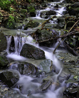
Figure 1. As streams flow towards the ocean, they carry weathered materials.
Erosion by Streams
Flowing streams pick up and transport weathered materials by eroding sediments from their banks. Streams also carry ions and ionic compounds that dissolve easily in the water. Most rocks and minerals are much denser than water. Sufficient energy in the stream is required to dislodge rocks from the earth and move them. The faster a stream flows, the more energy it has and the larger pieces of sediment it can transport. The competence of a stream refers to the maximum size of the pieces of sediment it can move. Faster-moving water has greater competence and can move larger pieces of sediment.
The capacity of a stream is the total amount of sediment it can move. Capacity depends on how fast the stream is moving and its total discharge. The competence of the stream is the size of the largest particle it can carry. As a stream slows down, its competence and capacity are reduced. The stream starts to deposit sediment, beginning with the largest pieces. Several factors cause a stream to slow down, including the stream channel widening, the stream overflowing its banks and spreading into a floodplain, the stream gradient (downhill slope) diminishing, and the stream emptying into a larger, slower moving body of water.
Sediment Load
Streams transport clastic sediment in two ways depending on the size of the particles.
Sediments are carried as:
- Dissolved load: Dissolved load is composed of ions in solution (e.g. phosphorus, arsenic, etc.). These ions are usually carried in the water all the way to the ocean.
- Suspended load: Sediments carried as solids as the stream flows are suspended load. The size of particles that can be carried is determined by the stream’s velocity (figure 2). Streams that carry larger particles have greater competence. Streams with a steep gradient (slope) have a faster velocity and greater competence.
- Bed load: Bed load consists of particles too large to be suspended in the moving current of water for an extended length of time. The bed load particles, the largest particles of sediment transported by a stream, spend most of their time on the bottom of the stream channel, rolling, sliding, or saltation (when small pebbles and gravel move up and down along the water flow).n. Streams with high velocities and steep gradients do a great deal of down cutting into the stream bed, which is primarily accomplished by movement of particles that make up the bed load.
- Here is a video of bedload transport.
- Stages of Streams: headwaters, meanders, braided streams, floodplains, base level.
- As a stream flows from higher elevations, like in the mountains, towards lower elevations, like the ocean, the work of the stream changes. At a stream’s headwaters, often high in the mountains, gradients are steep (figure 3). The stream moves fast and does lots of work eroding the stream bed.
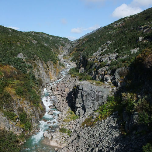
Figure 3. This stream begins as snow melt from the mountains.
- As a stream moves into lower areas, the gradient is not as steep. Now the stream does more work eroding the edges of its banks. Many streams develop curves in their channels called meanders (figure 4).
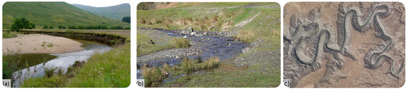
- Figure 4. (a) At a meander, a stream actively erodes its outer banks and deposits material along the inside curves. This causes these meanders to migrate laterally over time. (b) This stream has deposited larger materials such as gravel and pebbles along the inside curve of a meander. (c) This image is a topographic map.
- The San Juan River eroded the land surface as the Colorado Plateau uplifted. The river’s meanders were preserved as a feature called incised meanders.
Meanders
A stream running down a slope, even the gentle slope of a floodplain, will seldom follow a straight path for very long. Depending on the distribution of sediments and turbulence of the stream, one side of the channel may erode more easily than the other. The stream will migrate toward the area undergoing erosion, developing a curve in that direction. Once the stream channel has begun to curve, the energy of the water is concentrated on the outside of the curve.
The diagram shows a stretch of stream channel with a significant bend, also known as meander. The blue line shows how erosive energy is concentrated along the outside of each bend in the stream. As erosion occurs on the outside bank of a meander, deposition occurs on the inside bank where the water slows and drops sediment.
- Figure 6.
The diagram below shows two well-developed meanders that have formed in a stream. Along each meander, the outer stream bank that is being cut into by erosion is called a cut bank. The inner bank, which has grown by accretion of deposited sediment, is called a point bar.
- Figure 7.
In a stream, meanders enlarge and migrate downstream because the stream continually erodes its cut banks and grows its point bars. The diagram below shows the enlargement and downstream migration of a meander in a stream channel. As the meander is enlarged, its neck gets narrower. Eventually, the stream may cut through the neck of the meander, either as a result of gradual erosion and channel migration, or abruptly during high water and flooding. Once the stream has cut through the neck of the meander, the openings get filled with sediment dropped by water that slows down as it enters from the main stream. The sediment deposits will separate the cut off meander from the river channel and turn it into an oxbow lake. As the years go by, the oxbow lake will eventually be completely filled in with sediment because it is a low spot on the floodplain where any water that enters, such as during flooding, will come to a standstill and deposit its sediment load.
Figure 8.
Braided Streams
Rather than a single channel, some streams have multiple channels that weave in and out of each other forming what is known as a braided stream. Braided streams are associated with excessive amounts of sediment entering a stream system. Valleys draining alpine glaciers are common settings for braided streams. The glaciers deposit more sediment into the meltwater stream system than a stream of that discharge has capacity to transport in a single channel system. Braided stream systems are indicators that there is an additional source of sediment in the system besides the stream itself. Sources of excess sediment that lead to braided streams include glaciers, eruptions of pyroclastic material by volcanoes and landslides.
Examples of various types of braided streams:
https://pages.uoregon.edu/millerm/braided.html
Floodplains
Streams build floodplains through a combination of erosion and deposition at lower gradient stretches of stream valleys. Although a floodplain has a general downhill slope consistent with the overall stream gradient, a floodplain is relatively flat. An example is a Vistula river (Poland) floodplain, which is a flat level area surrounding the stream channel (figure 5).
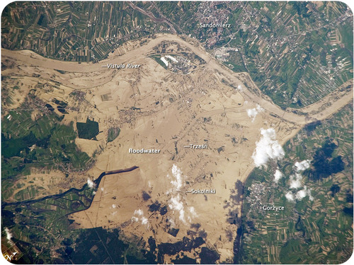
Figure 5. The Vistula River in Poland flows onto its floodplain.
Base level is where a stream meets a large body of standing water, usually the ocean, but sometimes a lake or pond. Streams work to down cut in their stream beds until they reach base level. The higher the elevation, the farther the stream is from where it will reach base level and the more cutting it has to do.
Stream Deposition on a flood plain
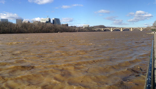
As a stream gets closer to base level, its gradient lowers and it deposits more material than it erodes. On flatter ground, streams deposit material on the inside of meanders. Placer mineral deposits, described in the Earth’s Minerals chapter, are often deposited there. A stream’s floodplain is much broader and shallower than the stream’s channel. When a stream flows onto its floodplain, its velocity slows and it deposits much of its load. These sediments are rich in nutrients and make excellent farmland (figure 6).
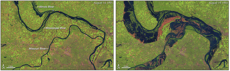
- Figure 6. The Mississippi floodplain is heavily farmed. Flooding can wipe out farms and towns, but the stream also deposits nutrient-rich sediments that enrich the floodplain.
A stream at flood stage carries lots of sediments. When its gradient decreases, the stream overflows its banks and broadens its channel. The decrease in gradient causes the stream to deposit its sediments, the largest first. These large sediments build a higher area around the edges of the stream channel, creating natural levees (figure 7).
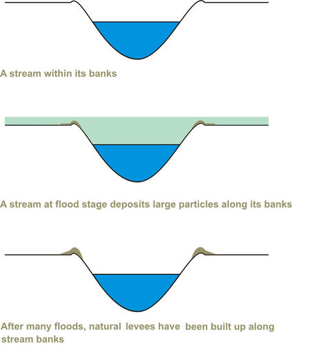
Figure 7. After many floods, a stream builds natural levees along its banks.
Base Level: alluvial fans, delats
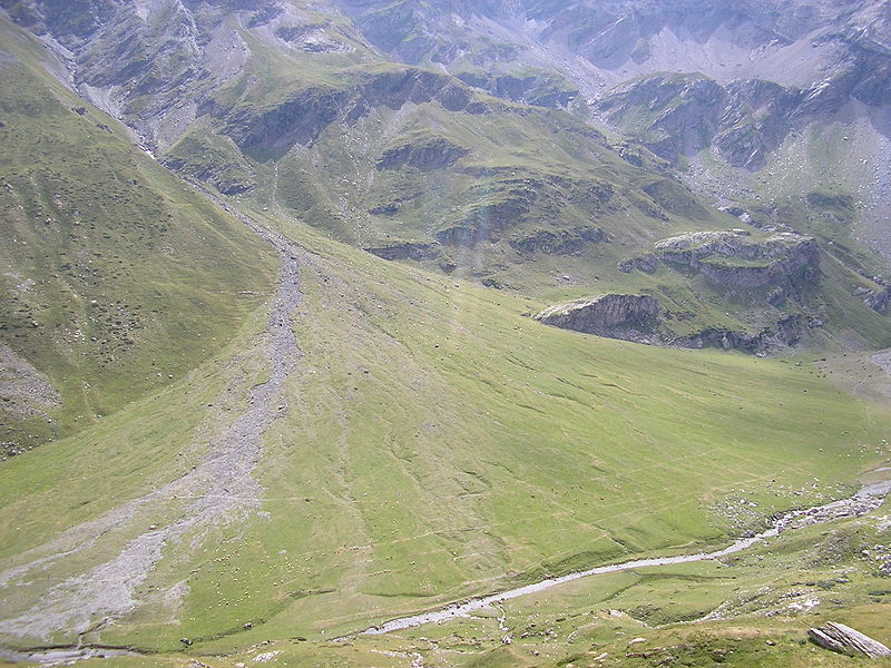
Figure 10.
At the location where a stream reaches its base level, it slows down and deposits nearly all of the sediment it is carrying. A stream that comes down a canyon and enters a flat valley or plain builds a fan shaped deposit of sediment known as an alluvial fan. Alluvial fans are built mostly during flash floods. Alluvial fans are easy to recognize in arid areas but they form in wetter climates as well.
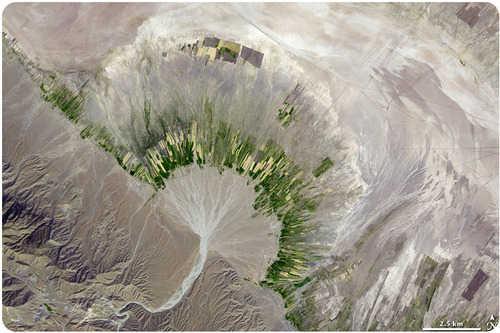
Figure 9. An alluvial fan in Iran. The mountains are in the lower right corner of the photograph.
Deltas
When a river enters standing water, its velocity slows to a stop. The stream moves back and forth across the region and drops its sediments in a wide triangular-shaped deposit called a delta (figure 8).
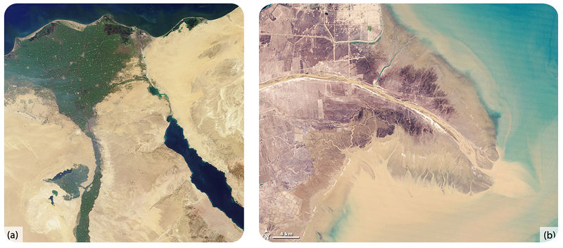
- Figure 8. (a) The Nile River delta has a classic triangular shape, like the capital Greek letter delta. (b) Sediment in the Yellow River delta. The main stream channel splits into many smaller distributaries.
Deltas are important landforms to civilization. They provide fertile soils, flat land, and water for agriculture, as well as river channels for transportation.
A delta is a landform composed of sediment deposited where a stream enters a larger, slower moving body of water, such as an ocean, a lake, or a larger river. The term delta comes from the triangular shape of the Greek letter delta (Δ). Ancient Greek geographers recognized the triangular shape of the land created by the Nile River where it emptied into the Mediterranean Sea and gave the name delta to that landform. The Nile River delta is one of several types of deltas that are defined by the predominate processes that shape them. The Nile delta is a wave-dominated delta. Waves of the Mediterranean Sea have pushed and distributed sediment along the coast, flattening the seaward side of delta.
The Mississippi River delta is an example of a stream dominated delta. Deposition of sediments has built the delta into the Gulf of Mexico faster than waves or tides could redistribute the sediment. As commonly occurs in a delta, the Mississippi River splits in the downstream direction into several branches that discharge across the delta into the Gulf of Mexico. These branches are known as distributaries. The mouth of each distributary has built part of the delta farther out into the Gulf of Mexico forming what is known as a bird’s foot delta, another name for a stream dominated delta based on the way it looks on a map.
The Ganges River delta is a tide dominated delta formed from sediment eroded from the Himalaya Mountains, the largest mountain range in the world. The mouth of the Ganges River is at the northern end of the Bay of Bengal, a large embayment of the Indian Ocean. The shape of this large bay has a magnifying effect on the tides. The combination of strong tides and the consistently high discharge from a river caring a large sediment load create a branching pattern of distributaries, in effect a braided stream system across the delta.
Deltas are lowlands that lie barely above sea level and are at high risk of being submerged under water. There are several ways in which deltas can be inundated by rising water. Floods coming down the river can cover a delta. Marine deltas can be subject to storm surges when extreme winds raise sea level along the coast and push ocean water inland. In the last several decades a new risk of submergence has arisen for marine deltas. Many marine deltas are undergoing gradual submergence as global sea level rises.
Earth Observatory (NASA) articles and images on world deltas:
