75 Coastal Hazards
Natural geomorphic processes are considered hazards when human populations are affected by them. For example, storms, hurricanes, and tsunamis are natural driving forces of coastal processes and landforms, but also cause loss of life and property in coastal communities. Storms provide much of the sediment to shallow-marine and estuarine ecosystems. Many wetland environments and barrier islands depend on storm activities for sediment build-up and survival when faced with rising sea levels. When combined with increasing sea levels, these events may have tremendous impacts on coastal environments and beaches.
Coastal Erosion
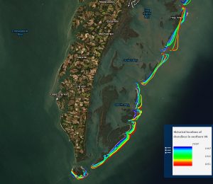
Coastal erosion is a hazard that requires long-term observations of the coastline fluctuations. It is affected by natural (climate change, sea-levl rise, coastal geology, etc.) and anthropogenic (man-made) influence (e.g. dredging, construction, etc.) In 1999 USGS issued a report on National Assessment of coastal vulnerability to sea-level rise with objective to determine the relative risks due to future sea-level rise for the U.S. Atlantic, Pacific, and Gulf of Mexico coasts.

Rip Currents
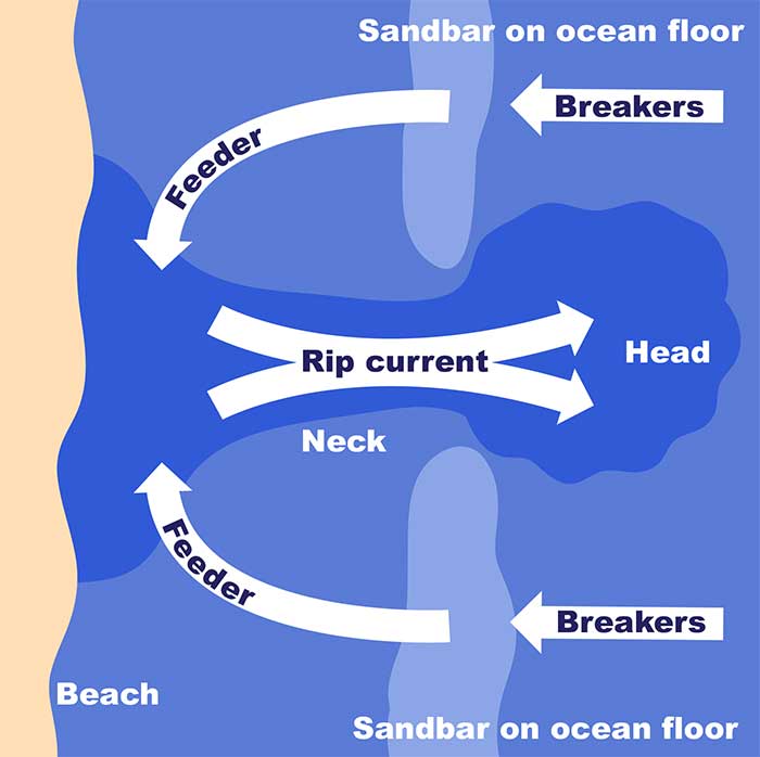
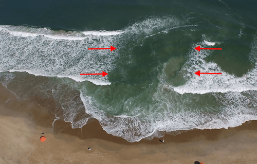
Rip currents are strong and swift, moving 3 to 6 feet (1 to 2 m) per second, which is faster than an average person can swim! These currents are created because of “set-up” near the shoreline. Set-up is a slight increase in water levels compared to those found seaward of the surf zone and creates unstable conditions that eventually are relieved through the formation of rip currents. These dangerous currents generally form at a low point or saddle in a sandbar. Because rip currents tend to be narrow, swimmers caught in a rip current should swim parallel to the shore to escape being taken out to sea. Swimmers should be especially cautious during storm events, which may increase the frequency and strength of rip currents.
 Sources: https://scijinks.gov/rip-currents/
Rip Current Video (with marker sprayed in the water):
https://oceantoday.noaa.gov/ripcurrentscience/
Storm Surges
Storm surges—extraordinarily high water levels—are generated by the combined effects of low atmospheric pressure and very high wind speeds. The strong onshore winds that accompany tropical storms, hurricanes, and frontal storms of the midlatitudes drag and stack water against coasts, creating a storm surge. In the center of tropical-storm systems, atmospheric pressure may drop as much as 100 millibars below normal, and this can “suck up” sea level below the center of the cyclone by as much as 3.3 feet (1 m) (Summerfield 1991). Winds blowing toward coastal embayments produce the largest storm surges, which are accentuated if they coincide with high tides. By the time the waves generated by the storm surge reach the coast, they may have built up to a height of nearly 10 feet (several meters) above normal high tides.
When low-pressure storm systems approach land, strong winds can affect a coast in a variety of ways. High velocity onshore winds, particularly the kind associated with hurricanes, drive water ashore and elevate the water line well above the predicted tidal variation. The effect of storm surges can be catastrophic because the elevated water surface results in widespread coastal flooding and allows waves to break much further inland than they would normally. In addition, torrential rainfall associated with the storm causes widespread river flooding. The combination of these effects can result in extensive property damage and loss of life (Pinet 1992).
Storm surges are most destructive along very low-lying coasts where their effects can extend many miles (kilometers) inland, but their geomorphic significance arises in large part from the way in which they lead to wave attack at much higher levels along a shoreline than is reached by normal waves.
For more information about hurricanes, check out these Web sites:
Tsunamis
Tsunamis are very large seismic ocean waves that are radially generated from volcanic eruptions, earthquakes, or subaqueous slumping. In the open ocean, these waves may travel at speeds in excess of 493 miles per hour (793 kph)! Strangely, sailors on deep ocean vessels may not notice the passing of these waves on account of the waves’ flat, low propagation. In contrast, when tsunamis reach shallow water, they slow down considerably and may reach great heights [up to 33 ft (10 m)]. Tsunamis have caused great destruction and loss of life because of abrupt changes in water levels above the normal high water mark. Numerous areas in the United States have experienced tsunamis including Hawaii, the Pacific Northwest, and Alaska. A new system, the International Tsunami Warning System, is used now to alert the public to impending tsunamis.
